
Training events can be found by searching in the EUMETSAT User Portal.
Documents associated with EPS-SG, including Algorithm Theoretical Basis Documents, can be found on the Metop-SG resources section of the EUMETSAT User Portal.
Author Archives: eum-generic
EPS-SG User Notification and Feedback
Alerts and planned maintenance messages relating to EPS-SG can be found in the Alerts and Notifications area of the user portal. The point of contact for all user queries will be the EUMETSAT User Service Helpdesk, which is open from Monday to Thursday 08:30–17:15 CET, Friday 08:30–16:00 CET. Helpdesk contact details.
To leave a comment, please go to the posting details.
EPS-SG Software Tools
Software and tools for EPS-SG data can be found in the EUMETSAT User Portal.
To leave a comment, please go to the posting details.
EPS-SG Basics
 EPS-SG is EUMETSAT’s next generation of polar-orbiting satellites, following on from earlier successful EUMETSAT Polar System programme (Metop). This next generation will secure the continuation of meteorological observations from polar orbit from 2025-2043.
The EPS-SG mission will have two series of spacecraft, Metop-SG A, the first of which was launched on 13 Aug 2025, and B, flying on the same mid-morning orbit, like the current Metop satellites. The orbit height is in the range 823-848 (dependent on latitudes). There will be three satellites each of Metop-SG A and Metop-SG B.
Metop-SG A is an atmospheric sounding and imaging mission. It has a suite of infrared, microwave, and imaging instruments for sounding temperature, moisture and trace gases in the atmosphere:
- Infrared Atmospheric Sounding Interferometer (IASI-NG)
- Microwave Sounder (MWS)
- METimage
- Multi-viewing, Multi-channel, Multi-polarisation Imager (3MI)
- Sentinel-5 instrument
Metop-SG B is a microwave imaging mission, focused on radar observations of ocean-surface wind and soil moisture and all-weather microwave imagery of precipitation and ice clouds:
Both satellites are equipped with a Global Navigation Satellite System (GNSS) Radio-Occultation (RO) instrument for limb sounding of temperature and humidity at high vertical resolution.
Ground Segment
The EPS-SG Overall Ground Segment (OGS) will support the ground functions required to meet the EPS-SG Missions objectives.
Main functions of the OGS:
- Acquiring, processing and disseminating EPS-SG global and regional data to the end users, as part of the EPS-SG Global and Regional missions.
- Monitoring, controlling and operating the Metop-SG satellites in orbit.
- Archiving EPS-SG global data and providing off-line retrieval from archive and user support services.
- Perform calibration and validation of the products, routinely monitoring the Metop-SG instruments’ health, and product quality.
The ground segment consists of:
- Mission Control and Operations (MCO) — The MCO block will ensure the end-to-end monitoring and control of the Metop-SG spacecraft, including Tracking, Telemetry and Control (TT&C).
- Payload Data Acquisition and Processing (PDAP) — The PDAP block will ensure the end-to-end chain from data acquisition to the generation of level 1 and level 2 products.
- EUMETSAT Multi Mission Elements (MMEs) — The Multi Mission Elements (MMEs) are EUMETSAT operational facilities and common infrastructure used by existing programmes. They are split in four groups: infrastructure, data centre, monitoring and dissemination. They will be used by EPS-SG after extension and upgrade.
Further information on the Metop-SG spacecraft, instruments and services can be found on Metop-SG section of the EUMETSAT User Portal.
To leave a comment, please go to the posting details.
EPS-SG User Readiness Planning
The EUMETSAT User Portal is now the one-stop-shop for all user information related to EPS-SG. The Metop-SG section includes an overview of the mission and data services (Global, Local, Regional); Metop-SG Data collection (post-launch, when closer to release); resources including user guides, related documents, software and code and service status updates, and Metop-SG data news and events.
In order for users to prepare for EPS-SG, format familiarisation test data packages are being released. A Product Format Specification document describing the content of each product is also released with each test data package. For more information on test data, see the Metop-SG test data user guide.
To leave a comment, please go to the posting details.
EPS-SG Instrument Performance
Information on instrument performance will be available from the Service status section of the EUMETSAT User Portal.
To leave a comment, please go to the posting details.
EPS-SG Long-term Operations Plan
EUMETSAT Polar System – Second Generation (EPS-SG) will see the launch of six new satellites, the first of which, Metop-SG A1, was launched on 13 August 2025. The EPS-SG programme should guarantee access to space-acquired meteorological data until at least the early 2040s.
Planned deployment of the satellites can be found in the Satellite service and history table in the Metop-SG section of the EUMETSAT User Portal.
To leave a comment, please go to the posting details.
EPS-SG Data, Products and Applications
All EPS-SG global and Regional Level 1 and L2 products generated at EUMETSAT headquarters will become available post-launch. A full list will be available in the data catalogue of the EUMETSAT User Portal.
While all the products will be generated centrally at EUMETSAT, some of them will be developed and validated within the SAF Network or by ESA.
To leave a comment, please go to the posting details.
EPS-SG Data Formats and Volumes
Information to come.
To leave a comment, please go to the posting details.
EPS-SG Data Access Mechanisms
Global Data Service
The instrument data will be provided to the users in near real-time, after their acquisition and processing by the ground segment to obtain geometrically consistent and calibrated radiance values, and a number of geophysical variables with global coverage. Processed data will be transmitted to users primarily via EUMETCast. Meteorological data and products will also be sent and relayed via the WMO Global Telecommunications System (GTS) and the Regional Meteorological Data Communication Network (RMDCN) to the National Meteorological Services and ECMWF.
Regional Data Service
The regional data service uses a network of direct broadcast data receiving ground stations to rapidly transmit data from a defined geographical Area of Interest (AOI) to users. The baseline regional AOI currently covers the North Atlantic and European regions between 30° to 80° North and 65° West to 50° East, as shown as the red box in Figure 3.
The plan is to re-use selected existing EPS EARS direct broadcast station sites to cover the AOI and add complementary stations as necessary.
Data received at the stations is transmitted in real-time to EUMETSAT Headquarters for processing and transmission to end users via EUMETCast. AOI data will be delivered to users within 30 minutes of sensing, making it suitable for short range regional numerical weather prediction models.
Not every satellite orbit will be visible from the AOI. Over five days there will be 24 descending and 28 ascending passes over the AOI, i.e. about three-quarters of the orbits will have some degree of visibility over the AOI, either on their ascending or descending parts.
Direct Data Broadcast Service
Instrument data will be broadcast in real-time by the satellites to receiving stations in visibility of the satellite (direct broadcast). This transmission will be in X-Band and allow reception via an antenna of approximately three metres (depending on local conditions and quality of the antenna system) and a user station. Data is only available for the field of view of the satellite, but it is available in real-time.
To leave a comment, please go to the posting details.
EPS-SG Software Tools and Test Data
Information to come.
To leave a comment, please go to the posting details.
EPS-SG User Notification and Feedback
The existing EUMETSAT User Notification Service will be enhanced to incorporate service messages relating to EPS-SG. The point of contact for all user queries will be the EUMETSAT User Service Helpdesk, which is open from Monday to Thursday 08:30–17:15 CET, Friday 08:30–16:00 CET. Helpdesk contact details.
To leave a comment, please go to the posting details.
EPS-SG Training and Resources
When available, documents associated with EPS-SG, will be added to the Technical Documents page on the EUMETSAT website.
To leave a comment, please go to the posting details.
MTG Basics
Meteosat Third Generation (MTG) is EUMETSAT’s next generation of geostationary satellites, following on from earlier successful missions.
This next generation, following on from Meteosat Second Generation, provides an evolution of the imaging service, including a new Lightning Imager, and a state-of-the-art atmospheric sounding service providing measurements in the infrared and ultraviolet spectrum.
To achieve these services, MTG will see the launch of six new geostationary satellites, with the first satellite (MTG-I1) having been launched in December 2022. The satellite series is based on 3-axis platforms and comprise:
- Four Imaging Satellites (MTG-I) (20 years of operational services expected)
- Two Sounding Satellites (MTG-S) (15.5 years of operational services expected)
The full operational configuration will consist of two MTG-I satellites operating in tandem, one scanning Europe and Africa every 10 minutes, and the other scanning only Europe every 2.5 minutes, and one MTG-S satellite.
Further details on the instruments onboard the MTG satellites, can be found in the user guides linked below
- Flexible Combined Imager (FCI)
- Lightning Imager (LI)
- Infrared Sounder (IRS)
- Ultraviolet Sounder (UVN) (to come)
Ground Segment
The Meteosat Third Generation Ground Segment acquires data from all the MTG satellites, and generates, archives and distributes the products. It also provides the capabilities to command and control the satellites and the ground segment itself.
The ground segment consists of:
- The Telemetry, Tracking and Control (TT&C) ground stations — the TT&C interface between the Space Segment and the Mission Control Centre.
- The Mission Data Acquisition (MDA) ground stations — the payload data interface between the Space Segment and the Mission Control Centre.
- The Mission Operations Facility (MOF) — provides functions for the preparation, planning and operation of the system, including satellite and mission operations and flight dynamics.
- The Instrument Level 1 Data Processing facilities (IDPF-I and IDPF-S) — these extract the measurements from the sensors. They also perform a series of functions for the generation of level 1b data and the processing of level 1c data.
- Level 2 Processing Facility (L2PF), for the extraction of centrally generated products.
To leave a comment, please go to the posting details.
MTG User Readiness Planning
The EUMETSAT User Portal is now the one-stop-shop for all user information related to MTG. The Meteosat Third Generation section includes an overview of the mission and data services (0 degree, data collection service, rapid scanning service, sounding service); MTG data; resources, including user guides, related documents, software and code and service status updates, and MTG data news and events.
In order for users to prepare for MTG, format familiarisation test data packages are being released. A Product Format Specification document describing the content of each product is also released with each test data package. For more information on test data, see the MTG test data user guide.
For more information on timelines etc, see the MTG in operations user guide.
To leave a comment, please go to the posting details.
MTG Instrument Performance
Information on instrument performance is available from the Service status section of the EUMETSAT User Portal.
To leave a comment, please go to the posting details.
MTG Areas of Coverage and Observations Schedule
Flexible Combined Imager (FCI)
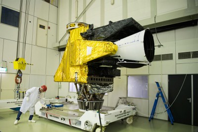
FCI instrument in at test centre. Credit: ESA
The Flexible Combined Imager (FCI) on the MTG-I satellite continues the very successful operation of the Spinning Enhanced Visible and Infrared Imager (SEVIRI) on Meteosat Second Generation (MSG).
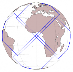
Requirements for the FCI were formulated by regional and global Numerical Weather Prediction (NWP) and Nowcasting communities. These requirements are reflected in the design which allows for Full Disc Scan (FDS), with a basic repeat cycle of 10 minutes, and a European Regional-Rapid-Scan (RRS) which covers one-quarter of the full disc with a repeat cycle of 2.5 minutes.
The FCI takes measurements in 16 channels, of which eight are placed in the solar spectral domain between 0.4 µm to 2.2 µm, delivering data with a 1 km spatial resolution. The additional eight channels are in the thermal spectral domain between 3.8 µm to 13.3 µm, delivering data with a 2 km spatial resolution. In the RSS mode two channels in the solar domain will be disseminated with advanced spatial resolution of 0.5 km. In the thermal domain two channels will have an advanced spatial resolution of 1 km. The scanning domain is the so-called LAC4 domain, with the wider Europe region enclosed.
| Channel | Centre Wavelength | Spectral Width | Spatial Sampling Distance (SSD) |
|---|---|---|---|
| VIS 0.4 | 0.444 µm | 0.060 µm | 1.0 km |
| VIS 0.5 | 0.510 µm | 0.040 µm | 1.0 km |
| VIS 0.6 | 0.640 µm | 0.050 µm | 1.0 km; 0.5 km* |
| VIS 0.8 | 0.865 µm | 0.050 µm | 1.0 km |
| VIS 0.9 | 0.914 µm | 0.020 µm | 1.0 km |
| NIR 1.3 | 1.380 µm | 0.030 µm | 1.0 km |
| NIR 1.6 | 1.610 µm | 0.050 µm | 1.0 km |
| NIR 2.2 | 2.250 µm | 0.050 µm | 1.0 km; 0.5 km* |
| IR 3.8 (TIR) | 3.800 µm | 0.400 µm | 2.0 km; 1.0 km* |
| WV 6.3 | 6.300 µm | 1.000 µm | 2.0 km |
| WV 7.3 | 7.350 µm | 0.500 µm | 2.0 km |
| IR 8.7 (TIR) | 8.700 µm | 0.400 µm | 2.0 km |
| IR 9.7 (O3 ) | 9.660 µm | 0.300 µm | 2.0 km |
| IR 10.5 (TIR) | 10.500 µm | 0.700 µm | 2.0 km; 1.0 km* |
| IR 12.3 (TIR) | 12.300 µm | 0.500 µm | 2.0 km |
| IR 13.3 (CO2 ) | 13.300 µm | 0.600 µm | 2.0 km |
Note: The channels VIS 0.6, NIR 2.2, IR 3.8 and IR 10.5 are delivered in both FDSS and RSS sampling configurations, the latter is indicated by * in the table.
Field of view of the Lightning Imager instrument
Lightning Imager (LI)
The Lightning Imager (LI), on board the MTG-I satellites, continuously measures at a wave-length of 777.4 nm with a very narrow bandwidth, with a spatial resolution 4.5 km at sub-satellite point, triggered by a variable threshold — optical pulses initiated by lightning emitting energy of larger than between 4 and 7 µJm-2sr-1.
The field of view (FOV) of the LI instrument is covered by four identical cameras on the instrument, each covering one out of four domains on the observable Earth disc.
Products derived from the instrument data are arranged around the following three categories:
- Events — what the instrument measures, a triggered pixel in the detector grid.
- Groups — neighbouring events in the same integration period (1 ms), representing a lightning stroke.
- Flashes — collection of groups in temporal and spatial vicinity (XX km, YY milliseconds), representing a lightning flash.
The LI complements the two NOAA GLMs (Geostationary Lightning Mapper) on the GOES-R and the GOES-S satellites, contributing, in the long term, to near global coverage.
Infrared Sounder (IRS)
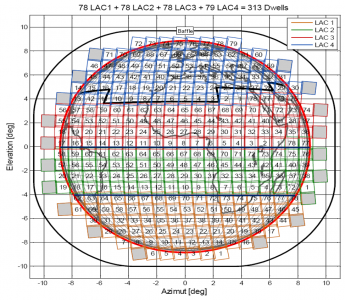
MTG Infrared Sounder dwell coverage
The IRS will deliver over the Full Disc in the Long-Wave Infrared (LWIR) 800 spectral channels and in the Mid-Wave Infrared (MWIR) 920 channels with a basic repeat cycle of 60 minutes.
The IRS is based on an imaging Fourier-interferometer with a hyperspectral resolution of 0.625 cm-1 wave-number, taking measurements in two bands, the Long-Wave Infrared (LWIR) and the Mid-Wave Infrared (MWIR), with a spatial resolution of 4 km.
Summary of technical specifications:
- Spectral bands: MWIR: 1600 to 2250 cm-1 (4.44–6.25 µm) and LWIR: 680 to 1210 cm-1 (8.26–14.70 µm).
- Full disc coverage in 60 min, Europe region (Local Area Coverage) 30 min.
- Onground resolution of 4 km x 4 km.
- Radiometric measurement ranges between 180 K and 313 K (equivalent black-body temperature.)
- Spectral radiometric noise (excluding spectral calibration) at 280 K black body: between 170 and 900 mK depending on the considered wave-number inside the band of interest
Ultraviolet Sounder
Instrument spectral bands and sampling domain
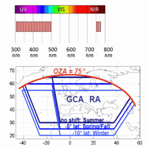
The Ultraviolet, Visible and Near-Infrared Sounding (UVN) instrument is a Copernicus Sentinel-4 instrument designed for geostationary chemistry applications. It will fly on board the MTG-S satellites
The UVN is a spectrometer taking measurements in the ultraviolet (UV: 305–400 nm), the visible (VIS: 400–500 nm) and the near infrared (NIR: 755–775 nm) with a spatial resolution of better than 10 km.
Its observations are restricted to Earth area coverage, from 30 to 65° N in latitude and 30° W to 45° E in longitude. The observation repeat cycle period will be shorter than or equal to one hour.
To leave a comment, please go to the posting details.
MTG Long-term Operations Plan
Meteosat Third Generation (MTG) will comprise of six new satellites, the first of which was launched in 2022. The MTG programme should guarantee access to space-acquired meteorological data until at least the early 2040s.
Planned deployment of the satellites can be found in the Satellite service and history table in the Meteosat Third Generation section of the EUMETSAT User Portal.
For more information on deployment of MTG services, data releases and more, see the MTG in operations user guide.
To leave a comment, please go to the posting details.
MTG Data, Products and Applications
MTG data and products generated by EUMETSAT Central Facilities, and the products generated by the EUMETSAT Satellite Application Facilities (SAF) are available in the data catalogue of the EUMETSAT User Portal.
For more information in the MTG data release schedule see the MTG in operations user guide.
To leave a comment, please go to the posting details.
MTG Data Formats and Volumes
NetCDF-4 is the baseline format for the FCI, LI and IRS instrument dataset generation. NetCDF-4 offers a number of advantageous features, including:
- Ability to cope with large dataset sizes — ~7 Gbytes for Full Disc archived dataset for MTG compared to the current ~220 Mbytes.
- Datasets are self describing.
- Groups allow potential for easier subsetting.
BUFR, GRIB and other formats will be used where there is already a product delivered in that particular format. See the Formats user guide for more details.
When available, further information is added to the Meteosat Third Generation resources section in the EUMETSAT User Portal.
To leave a comment, please go to the posting details.
MTG Data Access Mechanisms
The MTG data and products generated within the EUMETSAT Application Ground Segment are available through a number of delivery mechanisms, including EUMETCast and the Data Store.
For more details see the Data description and data access options section of the MTG in Operations user guide.
To leave a comment, please go to the posting details.
MTG Software Tools
Software and tools for MTG data can be found in the EUMETSAT User Portal.
To leave a comment, please go to the posting details.
MTG User Notification and Feedback
Alerts and planned maintenance messages relating to MTG can be found in the Alerts and Notifications area of the user portal. The point of contact for all user queries will be the EUMETSAT User Service Helpdesk, which is open from Monday to Thursday 08:30–17:15 CET, Friday 08:30–16:00 CET. Helpdesk contact details.
To leave a comment, please go to the posting details.
MTG Training and Resources
Training events can be found by searching in the EUMETSAT User Portal.
Documents associated with Meteosat Third Generation, including Algorithm Theoretical Basis Documents, can be found on the Meteosat Third Generation resources section of the EUMETSAT User Portal.
To leave a comment, please go to the posting details.
To leave a comment, please go to the posting details.